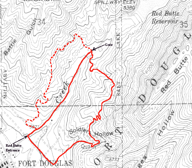
This trails starts at the south end of the Medical Center Trail and is reached in the same way: go up through Fort Douglas to the north entrance of Red Butte. Continue up the paved road, around the first gate, until you get to the second gate. Here there will be some steps down to a foot bridge on the right. Across this bridge you will come to more steps down to another bridge that crosses the creek. Cross this and up the steps on the far side. Here there are two trails, one that bears left and is blocked by a log and one bearing right; take the rightmost branch. From this point it is pretty much a steady climb over a rocky single track with frequent water bars, mostly made of rock.
Toward the high point of the climb, the surface of the trail turns red and more clay-like. As you crest at about 1.4 miles, you will pass through an expanse of wild flowers (in the spring and early summer that is). Then you begin the descent with the trail reverting to dust and loose rock. A little ways down you will abruptly encounter the first of four switchbacks, so be prepared. After going through the switchbacks you return to a gradual southward descent. At one point the single track splits, one fork heading up and left, the other down and right. They parallel each other and rejoin a hundred feet later so it doesn't matter which you take. At the point where they rejoin, you are entering Soldiers Hollow. Here you intersect a jeep road which heads to the left, up the hill ending at an old mine or quarry. Again stay right and head downhill toward the perimeter fence. After reaching the fence, you will turn back uphill to the east and skirt the fence heading south.
When you reach a sign at another uphill branch of the trail (there are steps up to this branch), the climbing is done. Now it is all downhill over a badly eroded trail with frequent water bars and two switchbacks. After the last water bar, the trail flattens out and you come to another trail intersection (2.1 miles) where there is a sign with a map showing various trails. Heading left will take you south and over to the Shoreline Trail. Take the right fork down over some more water bars til you intersect the pipeline road. Here you can again go left and over to Shoreline, or turn right across the paved entrance to the visitors center and back to the north entrance of Red Butte where you can pick up the Medical Center Trail.
Miles   Elev.  Landmark            Latitude, Longitude
 0.0    4990   Red Butte Garden
	       North Entrance
 0.75   5160   Gate
 1.4    5560   Highest point
 2.5    4990   Red Butte Entrance

Start up the same way you would to catch the south end of the Medical Center Trail: head east up the road until just before the first gate, turn left on the paved driveway and then bear right on the jeep trail that intersects on the right. Now, instead of turning left on the single track and straight up to the Med Center Trail, stay on the jeep trail. You will go around a gate at 0.3 miles and eventually start to climb to the northeast. The jeep trail ends at an underground tank of some sort at 0.5 miles, but a single track continues to climb along the ridge. Once the trail flattens out again you will pass through a clump of scrub oak where the trail splits (0.8 miles). The main trail continues to the right and a lesser used trail continues uphill. Stay right and you will start a gradual rolling descent along an occasionally narrow and rocky but mostly smooth single track.
At around 0.9 miles you drop quickly into a gulch from the side and the trail merges with another going directly up the gulch. Turn right (south) and down the gulch. By bearing left at the one remaining fork you will come out on the Red Butte road just before the gate and right across from the start of the Skyline Nature Trail.
This route adds about 0.4 miles to the loop bringing it to 2.9 miles.