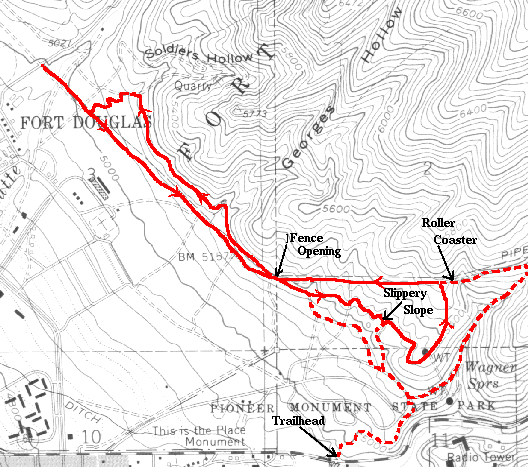
There are two approaches to this trail. One is from the official trailhead at the east end of TitP state park, the other is from the Red Butte Trail area. Coming from the University, I generally take the Red Butte approach. Head up through Fort Douglas to the north entrance of Red Butte. Go south through Red Butte following the pipeline road. Continue south across the paved Arboretum road along the gradually climbing dirt road. A half mile or so along, the road splits with a spur heading left and the main road continuing straight. Either way will get you to the trail, however, the upper road is generally considered the return route. Within another quarter of a mile you come to a chain link fence with a narrow gate, this is where the loop begins.
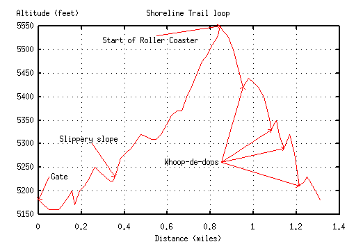
Start out heading downhill on the single track (roughly parallel to the fence). After a quick downhill, you come to a fork in the trail. The more interesting branch is to the left, the right branch is a mellow downhill cruise toward the trailhead. Along the left branch you will dive through some dips and up a last ``slippery slope,'' a short hard-packed slanting climb, and then intersects with a jeep trail. Again, right takes you down toward the trailhead. Left climbs up to the whoop-de-doos and back to the gate to close the loop. The climb is at first gradual as it contours around the hill east, south and finally back to the north. The last part of the climb gets steep and ugly as you head north to intersect the pipeline road. (I have heard this stretch affectionately referred to as ``Vomit Hill,'' though that no doubt is one of the most common names for a serious climb :-)
If you head right (east) at this point, you embark on the monstrous Roller Coaster. It is certainly worth taking a minute to walk over and look at the first drop and be thankful you are going the other direction. Now go west and start into the whoop-de-doos! The first is the rockiest and largest, the second is fairly minor and the third is smooth and fast. Chicken-shit that I am, I even take it with no brakes. The final one is most notable for a big climb up the other side. From there it is downhill back to the gate where you can take another loop or head back to the University.
If you head back to the U., take the rightmost (upper) road from the gate. This road runs parallel to the one you came out on. Shortly before it merges with that road, branch right into Georges Hollow. After crossing the drainage, there will be a trail on the right that goes uphill over some jutting rocks. Take that branch and you wind up on a very rocky jeep trail that brings you out at the Skyline Nature Trail sign near the start/end of the Red Butte Trail. Go right for a spin around Red Butte or left to descend back to the pipeline road where you can continue back to the U.
Miles   Elev.  Landmark                  Latitude, Longitude
 0.0    ????   ?
Another alternative from the service road is to start right and then immediately turn left on another road so you are heading generally northwest. After a short distance, a jeep trail spurs off on the right and up the hill. This intersects the main loop at the ``slippery slope'' where you can turn left reversing along the loop (not a great idea since most traffic comes the other direction) or continue straight ahead up to the whoop-de-doos.