Perrys Hollow (a.k.a. ``Bobsled'')
You gotta' pay to play here, but it is well worth the effort.
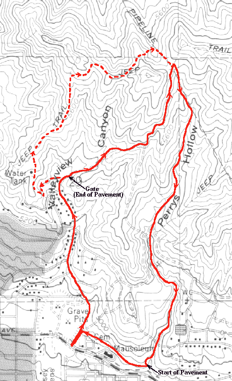
From the intersection of 11th Avenue and Terrace Hills Drive,
you ascend almost 1000 feet in 1.5 miles.
The first, and steepest, part of the climb is on pavement up to the
end of Terrace Hills Drive.
At the point where Terrace Hills Drive abruptly stops,
there is a gate off the right-hand side of the end.
You go around this gate
and up a jeep trail til you reach
a saddle between two small hills.
The trail continues in a northward direction up a hill,
but this is where you begin the descent to the east on a heavily-used
trail.
The first few hundred yards take you down to the stream bed where you
start the stretch from which this ride derives its nickname.
You follow the (usually dry) stream bed by crossing back and forth
making sweeping, banked turns on each side.
This last for about 0.5 miles til you intersect with another jeep trail
that crosses the stream bed.
From that point on it is a mix of minor climbs and drops, sand and rocks
and occasional low-hanging tree branches.
You wind up in a small basin where you make a last climb out and meet
up with a paved road which will take you back to Terrace Hills Drive
going right or on up to the ``U trail'' by going left.
This is a most excellent ride!
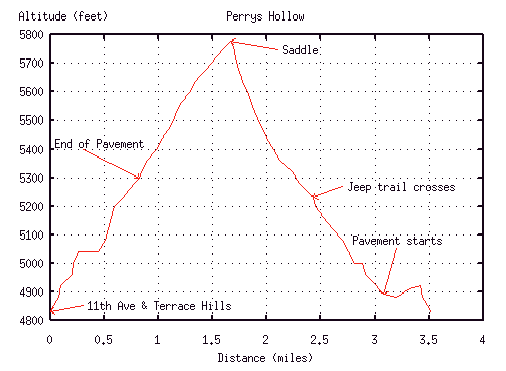
Miles   Elev.  Landmark             Latitude, Longitude
 0.0    4840   Intersection
 0.7    5300   End of pavement
 1.5    5780   Saddle
 ?.?	5230   Trail intersection
 ?.?    4920   Back to pavement
 ?.?    4840   Intersection
From Fort Douglas Quadrangle (Utah) 7.5 minute topo map
 If you don't feel the 0.8 miles from the end of the pavement to the saddle
is enough,
you can take an alternative climb (shown on the map) that will work your
legs a little harder.
Twenty feet or so before the end of Terrace Hills Drive there will be a
gate on the left hand side.
Go around this gate and head up toward the water tower.
The first 100 feet or so are deteriorating pavement which then turns into
a jeep trail.
The climbing really starts past the water tank as you do two short steep
climbs with a short respite in between.
After a quick downhill,
you start a third climb where you can see the trail ahead go up an
impossibly steep hill.
Fortunately, about half way up a single-track branches to the right and
traverses the hill, meeting up with the jeep trail 90 degrees around.
After a short downhill and another short, rocky climb you again are facing
another incredibly steep hill.
This hill is the southwesterly of the two hills forming the saddle which
marks the beginning of the descent.
Once again you are saved by a single-track, this time on the left.
This trail takes you around the hill and across a small plateau before
descending steeply through some trees and intersecting the pipeline road.
From there it is another short, steep climb back to the saddle.
If you don't feel the 0.8 miles from the end of the pavement to the saddle
is enough,
you can take an alternative climb (shown on the map) that will work your
legs a little harder.
Twenty feet or so before the end of Terrace Hills Drive there will be a
gate on the left hand side.
Go around this gate and head up toward the water tower.
The first 100 feet or so are deteriorating pavement which then turns into
a jeep trail.
The climbing really starts past the water tank as you do two short steep
climbs with a short respite in between.
After a quick downhill,
you start a third climb where you can see the trail ahead go up an
impossibly steep hill.
Fortunately, about half way up a single-track branches to the right and
traverses the hill, meeting up with the jeep trail 90 degrees around.
After a short downhill and another short, rocky climb you again are facing
another incredibly steep hill.
This hill is the southwesterly of the two hills forming the saddle which
marks the beginning of the descent.
Once again you are saved by a single-track, this time on the left.
This trail takes you around the hill and across a small plateau before
descending steeply through some trees and intersecting the pipeline road.
From there it is another short, steep climb back to the saddle.
There are also two alternatives on the descent.
At about the half-way point where the jeep trail crosses,
you can go right or left along the jeep trail.
Right takes you along an easy route back to the pavement in a subdivision.
Heading northwest along the paved road will bring you back to Terrace
Hills Drive about two-thirds of the way up.
Going left is another easy ride taking you to a gate at the end of a
paved road. (name?)
Going around the gate, you can take an immediate right on Perrys Hollow
Drive and then the next left on to Tomahawk Drive and then on to the
``U trail.''
Mike Hibler
<mike@cs.utah.edu>