Little Cottonwood Canyon
Elevation Profile
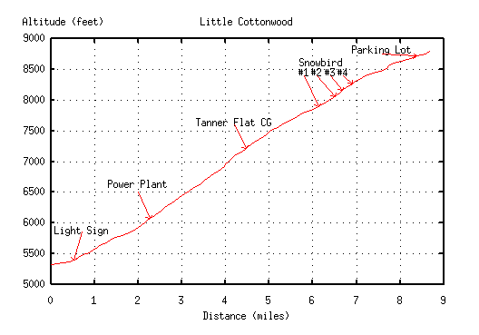
Details
Brutal.
8.5 miles of relentless climb with no shade and the constant aroma
of overheating radiators and tortured brake pads from passing cars.
The hardest part is a 1.5 mile stretch ending just beyond the
Tanner Flat campground.
It eases up slightly before the final climb past Snowbird and up to the
Alta parking lot where the pavement ends.
From the light sign to the end of the pavement is 8.5 miles and 3480
vertical feet.
If you are a real masochist you can keep on going up the dirt road to the
Albion Basin campground!
My P.R. is 78:00. (14:00 down!)
Road Distances
0.0 Light sign
1.9 Old power plant
4.3 Tanner Flat Campground turn off
6.0 Snowbird entry #1
6.4 Snowbird entry #2
(Hillclimb finish)
6.6 Snowbird entry #3
6.9 Snowbird entry #4
7.7 Alta Peruvian Lodge
8.5 End of pavement
Mike Hibler
<mike@cs.utah.edu>